
Galleri Oslo, “Soulside”
The new urban forms will invite to activity and social life.
TYPE OF PROJECT: Urbanism
LOCATION: Oslo
CLIENT: Galleri Oslo Utvikling
SIZE: ca. 120.000 m2
TIMEFRAME: 2012 - Ongoing
STATUS FOR PROJECT: Planning stage
With the new plan for Galleri Oslo, Vaterland and Grønland will be transformed into an accessible, including, safe, connected and sustainable part of Oslo. New forms of urbanity will be built into the heart of the city centre. The goal is to create a continuous urban floor, where new urban areas and spatial relationships cancel today's barrier effects.

The area is characterized by barriers and inaccessibility today; making orientation, mobility and understanding connections challenging. The plan involves a comprehensive restructuring of the urban fabric around the existing bus terminal in downtown Oslo. The existing traffic machine and ramps are planned to be demolished, reorganizing the road system to prioritize pedestrians and cyclists. Much of the existing buildings will be torn down as well, making room for more integrated structures that tie the area together. Akerselva will be opened and new parks and urban spaces established.
Old Vaterland og Grønland
Historically, old Vaterland and Grønland was situated on separate riverbanks on each side of Akerselva. The name Waterland was adapted from Dutch as they had a presence in the area through the timber trade in the 1600's. It was descriptive of a waterlogged grasslands area. From the mid-1600's, the main access road to the city from the East went across Vaterland bridge.
Bjørvika was gradually filled in during the period of 1670-1760; developing as a suburb. This character disappeared during the 1800's, when crowded tenement housing and industrial buildings appeared. During the next decade, the Garderners hall (Gartnerhallen), the Meat hall (Kjøtthallen) and the Slaughter house was established there, before an extensive redevelopment started in 1959 where almost all existing buildings, and many streets were torn down. The underground railway was constructed between Tøyen and Jernbanetorget, and the motorway was developed in the 1960's. Galleri Oslo opened as a bus terminal in 1989 and Vaterland park was constructed between 1993–94.

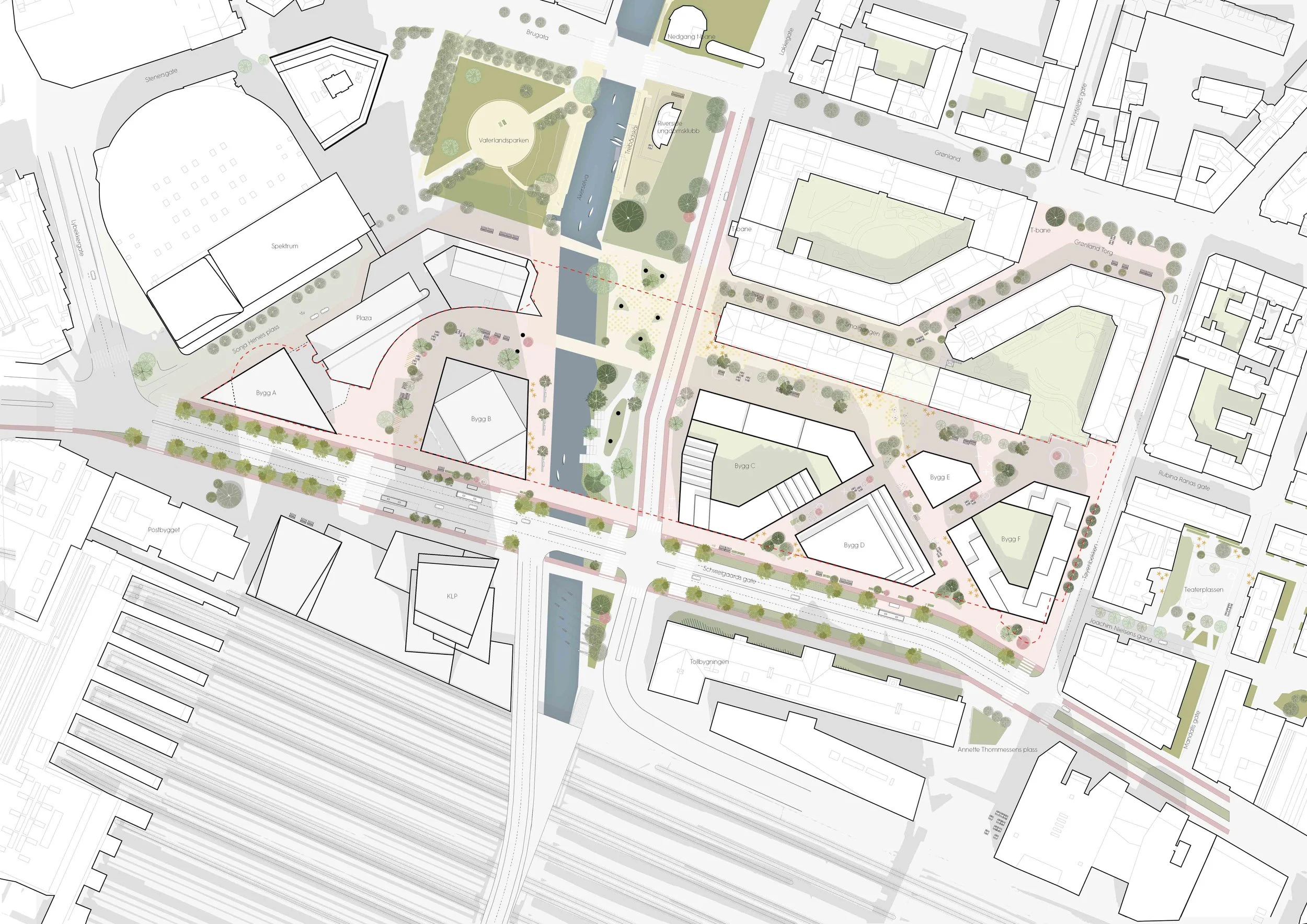
The planning area itself is occupied by Galleri Oslo, running alongside Schweigaards gate. The built mass has an area of 43 500 m² BTA (the underground level not included). Oslo bus terminal resides in it's first floor, with parking spaces outdoors and waiting- and service zones indoors. Today, Akerselva is covered and the building(s) and road system are perceived as barriers.
On each side of the Akerselva river culvert are underground car parking facilities. In 2017, a parallell comission was initiated to explore which possibilities a demolition of the existing Galleri Oslo could bring. A-lab's project "Soulside" was chosen to be developed further.

Streets, squares and urban spaces
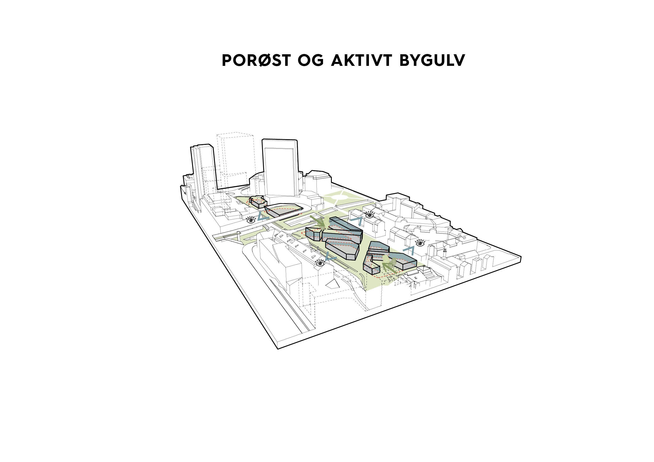
Several new connections and urban spaces that will tie the existing urban fabric together are suggested. The planning initiative suggests keeping the bus terminal on site, but placing it under street level to make room for active and integrative urban qualities on the ground floor. The terminal will then have access via ramps in Schweigaards street. In the case of a gradual development executed in stages, a solution on ground level can work as a temporary solution.
The planning initiative includes an upgrade of the streets. Schweigaards gate and Nylandsveien will be transformed into streets that prioritize collective traffic, pedestrians and cyclists. A complete restructuring of Nylandsbrua is suggested as well, by ramping down Nylandsveien to Schweigaards gate, so that the whole traffic machine north of Schweigaards gate can be torn down and the western ramp removed.
Akerselva and green structure
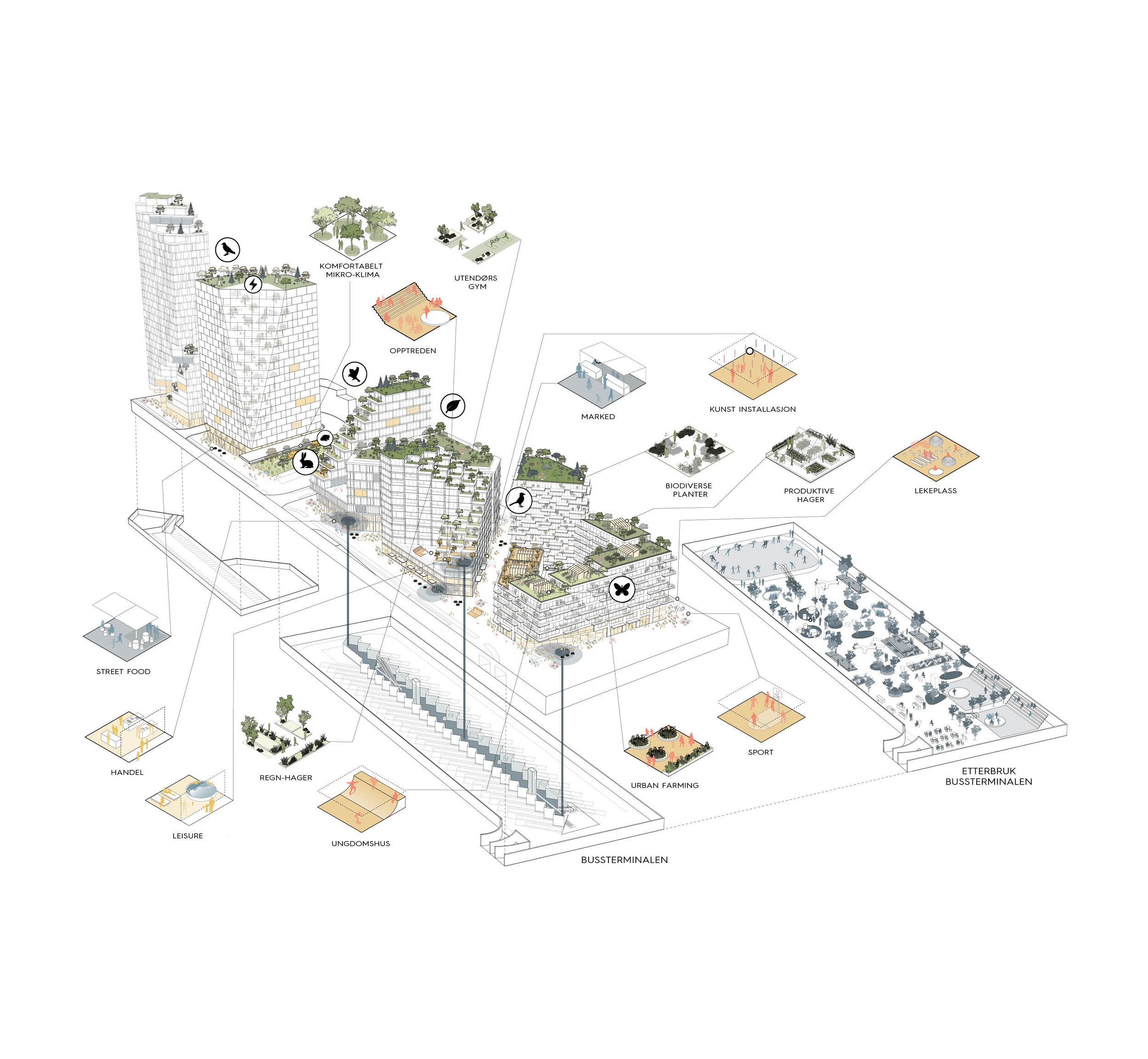
A key factor in establishing a sustainable plan for the area that uncovers and cultivates the inherent qualities of the site, is opening Akerselva. It will be re-established as a ventilation corridor, enhancing the micro climatic conditions. A long the same line, new green structure following the opening will contribute to water retention, supporting exisitng and future biotopes and habitats. Design of the will be executed with the support of ecologists, hydrologists, VA technicians and landscape architects to optimize blue-green solutions that are compatible with Akerselva's ecological and water-bearing premises. Akerselva will be opened up between Vaterlandsparken and the railway track area. An «Akerselvaallmenning», approximately 80 m wide, will be established, extending the existing Akerselva environmental park down this stretch.
The value of opening Akerselva will mainly appear after restructuring the road system. In line with that, the planning initiative can be carried out in stages, so that downscaling the road system will support a gradual opening of Akerselva.

Buildings and heights
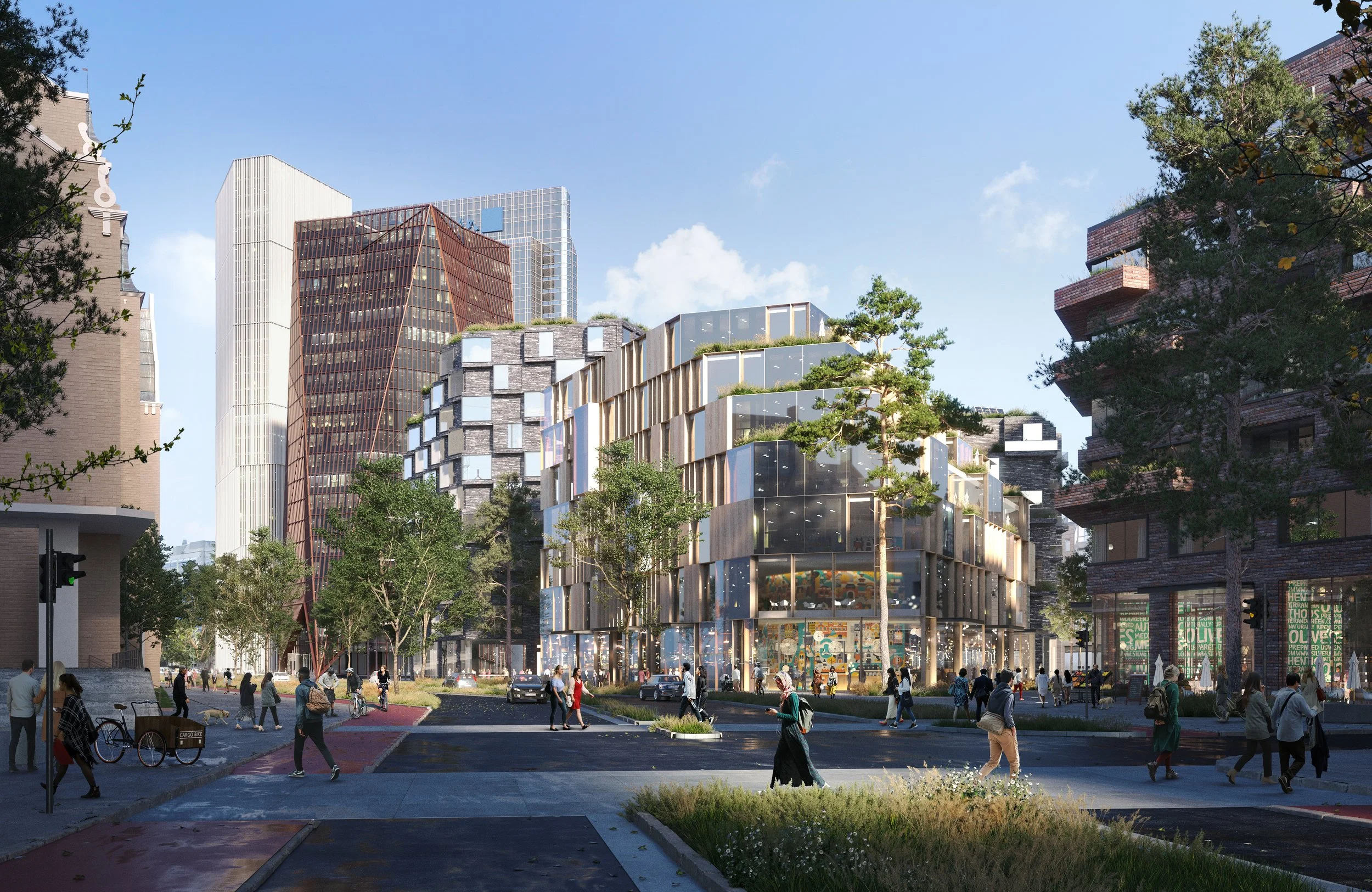
The reasons for replacing today's Galleri Oslo structure are many. In sum, they have to do with removing barriers, restructuring the road system, opening Akerselva and making room for the sort of buildings that invite activity and social life; resulting in an integrated city life. Elements and materials from the existing structure will be reused when possible; for example the building mass under ground, with reinforcements and extensions as required. A mapping of the structure above ground will be conducted to identify possibilities and limitations in reusing existing building materials.
The new development will increase the density and utilization of the area by facilitating the occurrence of more working places, service functions and housing in the Oslo-S area, making it a more active and attractive part of the city. The station area will thus be strengthened as a public transport hub, supporting the area plan for Oslo S and the municipality plan's developmental strategy pointing towards a compact, rail based development for the city centre.

On the west side of Akerselva, the high-rise buildings in the planning initiative lie within a zone designated for this purpose along Sonia Henies plass, Karl Johans gate and Akerselva (area plan for Oslo S). Two zones for taller, single high-rise buildings are alloted within the delimination, one by "Postens brevsenter" and one by Oslo S. The initiative shows a gradual reduction of height towards the surrounding buildings.
East of Akerselva, above today's bus terminal, the planning initiative shows buildings of varying heights, consisting of a mixture of office- and housing functions. The illustration project shows an initial 48% designated for housing in the eastern part. The distribution of area use will be considered more closely further into the planning process. Protected outdoor spaces on the roofscape and on a podium will be provided for the housing units, and enough area will be specified for a kindergarten. All the buildings on each side of the river have extroverted, accommodating functions on the first and some of the lower floors.
Multi-faceted sustainability
The aim is is to generate a communal project that gives a lot back to the city and the local environment through mulitifaceted, sustainable gains:
Environmental sustainability; through future oriented, climate friendly and circular energy solutions
Economical sustanability
Social sustainability; through information, involvement and participation